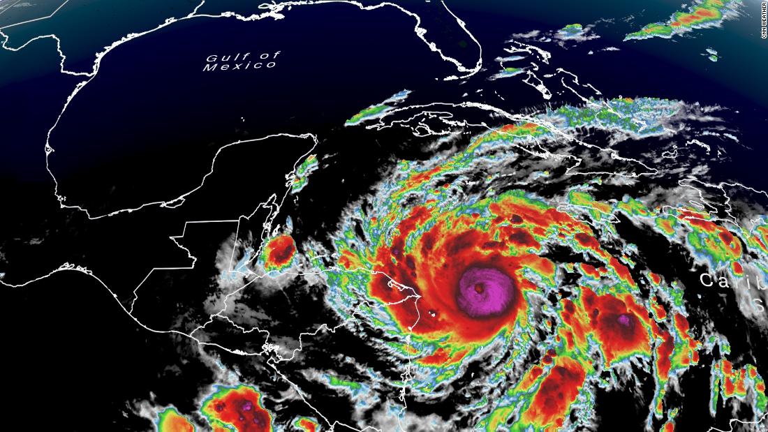
Portions of Central America could receive nearly 3 feet of rain, resulting in catastrophic flooding and landslides in some areas.
The National Hurricane Center (NHC) said Eta may transition into a Category 5 hurricane before it hits.
"Some strengthening is forecast during the next 12 hours, and Eta could become a Category 5 hurricane before it makes landfall," the NHC said in its 10 p.m. Monday advisory.
A Category 5 hurricane has sustained winds over 156 mph.
"Eta has become an impressive November hurricane as it continues to undergo rapid strengthening," the National Hurricane Center (NHC) said Monday afternoon.
Eta's wind speed went up 80 mph and more than doubled from 7 p.m. Sunday, when Eta was only a tropical storm, to 7 p.m. Monday. This is more than double the qualification for rapid intensification -- a wind speed increase of 35 mph in 24 hours.
Eta is now a dangerous Category 4 hurricane, with sustained winds of 150 mph and higher gusts, the NHC said Monday evening.
Eta is located about 70 miles from the Nicaragua/Honduras border and is moving to the west-southwest at 7 mph, according to the advisory from the NHC.
Conditions will deteriorate in Nicaragua throughout the night, with landfall expected early Tuesday.
"Continued strengthening is expected until Eta reaches the coast of Nicaragua," the NHC said. It will make landfall early Tuesday as a Category 4 hurricane, before moving inland over northern Nicaragua through early Wednesday.
Monday night, conditions were already beginning to deteriorate along the northeastern coast of Nicaragua, according to the NHC.
A hurricane warning is in place for the entire coast of Nicaragua. A tropical storm warning is in effect for the northeastern coast of Honduras.
Hurricane Eta is now the ninth storm of the year, and the fifth storm in a row, to undergo rapid intensification. Eta is now tied with Hurricane Laura as the strongest storm of the year in the Atlantic basin.
Hurricane Eta will bring Catastrophic conditions to Central America
"Catastrophic wind damage is expected where Eta's eyewall moves onshore within the hurricane warning area beginning tonight," the NHC said. The storm will also deliver heavy rainfall with estimates of 15 to 25 inches, and isolated amounts up to 35 inches in Nicaragua and Honduras.
Life-threatening storm surge along the Nicaraguan coastline is expected to be up to 18 feet above normal tide. Extremely strong winds will impact areas from the coast towards the mountains.
The wind and storm surge threat will diminish throughout Tuesday, but the rain will last well into the week.
Heavy rain will spread throughout Central America, where areas from southeast Mexico down through Panama could see rain accumulations up to 25 inches.
"This rainfall would lead to catastrophic, life-threatening flash flooding and river flooding, along with landslides in areas of higher terrain of Central America," the NHC said. "Flash flooding and river flooding would be possible across Jamaica, southeast Mexico, El Salvador, southern Haiti, and the Cayman Islands."
The current forecast has the storm meandering the mountains of Nicaragua and Honduras before heading north toward Belize as a depression by Friday. The track and intensity of the storm remains uncertain after Friday and will be closely monitored.
Eta is the 28th named storm of the active 2020 hurricane season and ties the record for the number of named storms in a single season set back in 2005.
The storm has the potential to be one of the worst flooding events Nicaragua has seen since Hurricane Mitch in 1998, which killed more than 10,000 people.
"now" - Google News
November 03, 2020 at 10:30AM
https://ift.tt/35QtNTM
Rapidly intensifying Hurricane Eta is now a major Category 4 hurricane bearing down on the coast of Nicaragua - CNN
"now" - Google News
https://ift.tt/35sfxPY
Bagikan Berita Ini


0 Response to "Rapidly intensifying Hurricane Eta is now a major Category 4 hurricane bearing down on the coast of Nicaragua - CNN"
Post a Comment