1 P.M. Cristobal update:
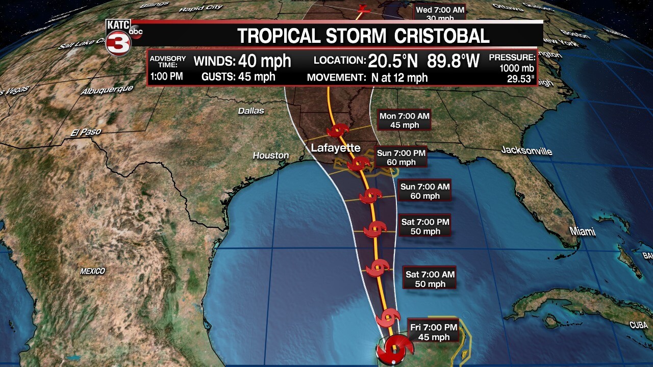
Cristobal is now back to Tropical Storm status as it continues to make its exist from the Mexican coast this afternoon and is expected to re-emerge into the Gulf of Mexico later on today.

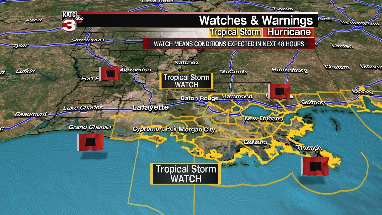
Tropical Storm WATCHES are in effect for Iberia, Vermilion, lower St. Martin, and St. Mary parishes at this time.
This means tropical storm conditions are to be expected in the next 48 hours in our area. We are expecting these watches to be upgraded to warnings sometime tomorrow.

The official track has shifted slightly to our east, but subtle changes in the track are to be expected.
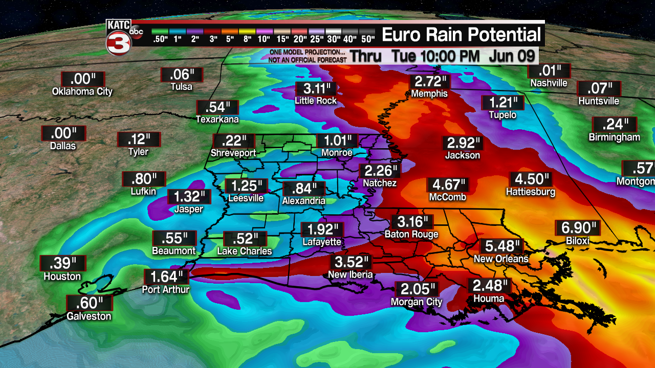
Bottom line is that we should be prepared for heavy rainfall, the potential for surge (especially along our coast), and gusty winds come Sunday afternoon and lasting through the day on Monday before conditions look to improve. Much more can be found on our website and apps. Updates now come in every 3 hours.
-------
A tropical storm WATCH is in effect from Intracoastal City to the Alabama/Florida state line. A storm surge WATCH is in effect from Grand Isle to Ocean Springs, Mississippi. Tropical Depression Cristobal is still expected to reach Louisiana as a strong tropical storm Sunday evening, with the main impacts to Acadiana overnight Sunday through Monday. It's currently over land near the Yucatan. Today, it's forecast to move northward and re-emerge over the Gulf of Mexico. It should be able to start getting its act together again and strengthen into a tropical storm.

There is a considerable amount of dry air to the west. Wind shear will also be an impact. Therefore a moderate tropical storm will be likely, while strengthening to a hurricane seems pretty unlikely now. But the track from the National Hurricane Center still pulls the system northward toward the Louisiana Gulf coast in about three days. Landfall is forecast to be Sunday evening, then tracking over Acadiana into central Louisiana by Monday evening. Gusty winds are expected along with heavy rainfall. Heaviest rains will be near and east of the center, with considerably lower amounts to the west.

Along the coast, depending on where the center approaches, tides may be higher than normal east of the center. Areas to the west of the center may see low water advisories posted as the flow comes in from the north. The effects will be felt starting late Sunday with those tides. Rainfall will start moving onshore by late Sunday into Monday. Heaviest rains will remain east of the center. Severe storms along with squalls will be most likely near and just east of the center. Wind speeds will exceed 40mph over many areas.

After Monday, rains should start to subside along with the winds. Some dry air will filter in late Tuesday with sunshine returning by Wednesday. The next update on coordinates and a new forecast track will be issued by the National Hurricane Center at 1pm.
------------------------------------------------------------
Stay in touch with us anytime, anywhere.
To reach the newsroom or report a typo/correction, click HERE.
Download our free app for Apple, Android, Roku and Amazon devices.
Sign up for newsletters emailed to your inbox. Select from these options: Breaking News, Evening News Headlines, Latest COVID-19 Headlines, Morning News Headlines, Special Offers
"now" - Google News
June 06, 2020 at 01:00AM
https://ift.tt/2XZGl7q
Cristobal now back to Tropical Storm status - KATC Lafayette News
"now" - Google News
https://ift.tt/35sfxPY
Bagikan Berita Ini


0 Response to "Cristobal now back to Tropical Storm status - KATC Lafayette News"
Post a Comment