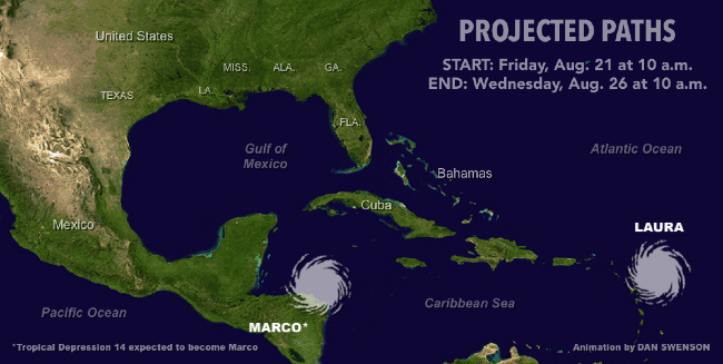
The latest forecast for Tropical Storm Laura has the New Orleans area at the dead center of the cone of uncertainty, with the storm expected to make landfall on the Gulf Coast as a Category 1 hurricane on Wednesday.
The shift to the west, included in a 4 p.m. advisory from the National Hurricane Center, comes as a second tropical system in the Gulf of Mexico - Tropical Depression 14 - is still predicted to strengthen into Hurricane Marco before striking the Texas coast on Tuesday. The NHC also shifted that track to the west in their advisory.
Dual storms in the Gulf haven't been seen in more than half a century, though experts say they are likely to remain too far apart to have much of an impact on each others' track or intensity.
Tropical Storm Laura
Laura is currently about 40 miles east of Antigua and moving west at 17 miles per hour with sustained winds of about 45 miles per hour.
A forecast discussion message by Senior Hurricane Specialist Richard Pasch notes the storm has a poorly-defined center and is expected to continue moving west until it reaches the end of a subtropical ridge before shift to the north.


Currently, the storm is expected to travel over the Dominican Republic, Haiti and Cuba as a tropical storm before growing into a hurricane in the Gulf. It is expected to make landfall around 2 p.m. on Wednesday, with the center of the forecast cone in southern Plaquemines Parish.
Pasch notes the official forecast predicts lower intensity and a track further to the east than the consensus of the models used by forecasters.
However, the forecast discussion notes that the long-range track and intensity of the storm are more uncertain than usual because the long time the storm system will be traveling over the Caribbean islands.
Tropical Depression 14
Tropical Depression 14 is is about 255 miles southeast of Cozumel, Mexico, and moving northwest at 13 miles per hour with maximum sustained winds of about 35 miles per hour.


A forecast discussion message by Hurricane Specialist Robbie Berg said it "is a bit of a mystery why the depression has struggled to develop much central convection, given a seemingly low-sheer environment and warm waters" in the Caribbean. However, because those conditions are forecast to continue for the next few days, the NHC is still expecting some intensification.
The storm is forecast to become a Category 1 hurricane after crossing over the Yucatan Peninsula before being sheared and weakened as it approaches the Texas Gulf Coast, Berg wrote. Winds are expected to drop back down to tropical storm levels as a result before the storm makes landfall sometime after 2 p.m. on Tuesday, according to the forecast.
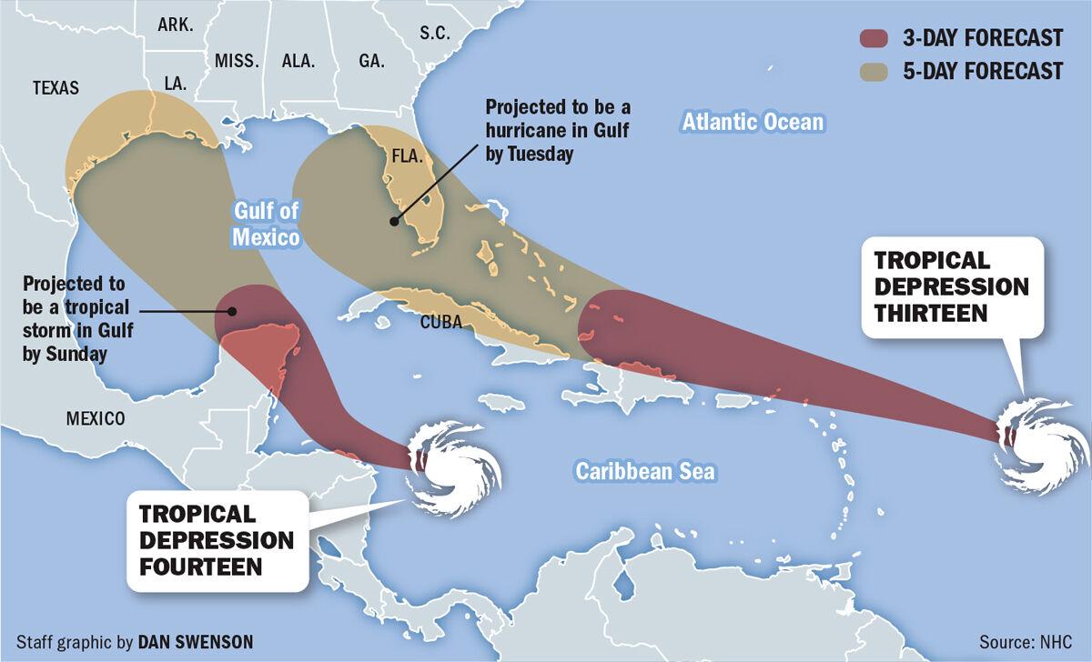

Two named storms could coexist in the Gulf of Mexico early next week, National Hurricane Center forecasters said Thursday.


Ahead of the possibility of two hurricanes entering the Gulf of Mexico next week, local officials are putting out sandbags for the public to prepare.
"now" - Google News
August 22, 2020 at 04:30AM
https://ift.tt/31i0N6g
Tropical Storm Laura track shifts west, now taking aim at New Orleans area; see latest forecast - NOLA.com
"now" - Google News
https://ift.tt/35sfxPY
Bagikan Berita Ini


Related Posts :
 Former Mrs. Bezos now richest woman in the world as Wall Street highs lead to reshuffling of top billionaires - NBC News
- Camas group's efforts to get cannabis on the ballot unsuccessful for now - clarkcountytoday.com
- Mortgage demand from homebuyers is now 28% higher than last year - CNBC
- Peninsula Health Group now has a new name: TidalHealth - Salisbury Independent
 Medvedev Spurred Cheers and Jeers at the Last U.S. Open. Now, He’ll Just Play. - The New York Times
0 Response to "Tropical Storm Laura track shifts west, now taking aim at New Orleans area; see latest forecast - NOLA.com"
Post a Comment